
WATERWEBTOOLS PLATFORM
The WaterWebTools Platform serves as the overarching architecture for a host of digital solutions allowing for maximum scalability, customization, and agility for client needs.
Our multi-source integration platform overlay with modeling, IoT, and weather data, and enables highly advanced forecasting and analysis.
AWARDS & RECOGNITIONS
Grant winning concept through the InnoExplorer program of Innovation Fund Denmark
Reviewed & accepted technology provider by the Water Research Foundation in the US
Reviewed & credited as noteworthy and tech ready by Innovation Radar of the European Union
EASY, SMART & SECURE
Serverless architecture with great scalability, high flexibility, and fast turnover from development to release of new products
Strong security controls on data, applications and networks through Amazon's AWS services
24/7 system monitoring – utilizing customizable warning levels for data classification and protection

Models
The WaterWebTools Platform supports a range of highly recognized hydrological and water quality models, including:
-
SWAT+ hydrological model for watersheds
-
GOTM-WET coupled hydrodynamic-ecosystem model for lakes, reservoirs and estuaries
-
Malstroem model for urban flood-screening
-
Machine learning models and other process-based models can also be implemented
-
Our partner WaterITech offers onboarding for all the model solutions supported by the WaterWebTools platform
Integrations with API
Data from the WaterWebTools Platform is easily visualized and analyzed through the intuitive UI, but the raw IoT and forecasted data can also be downloaded via API:
-
Currently supporting GraphQL API
-
Enables automatic download of raw data
-
Enables integration of data in your own solutions
Internet of Things
The WaterWebTools Platform can visualize data from any type of IoT device:
-
We can couple your sensors to the WaterWebTools Platform
-
Get a real-time overview of all your IoT devices
-
Integrate sensor data in our forecast solutions for improved forecasting
-
Examples of already included sensor types are temperature, oxygen, turbidity and chlorophyll sensors
Weather Data
The WaterWebTools Platform supports several global weather forecasts products for driving the hydrological and water quality forecasts, including:
-
The US based global GFS (Global Forecast System) forecast
-
The European based Yr (provided by Met Office Norway) global forecast
-
Other weather forecast products can also be implemented


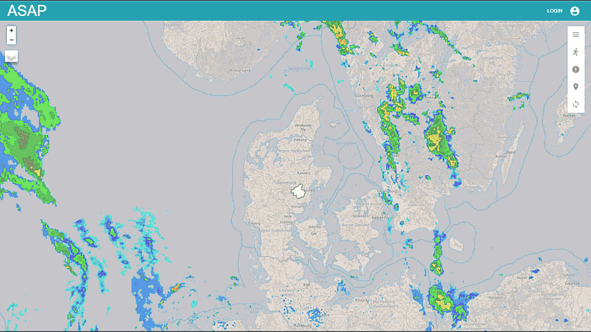
ASAP Rural
ASAP is short for A Scalable Prognosis, and is the name behind all our real-time and short-term forecasting solutions.
ASAP Rural is a novel software solution that enables eco-hydrological forecasts for any location in the world through a web-based platform. The system is a tool for early warnings and decision support to alleviate impacts of floods, drought, and water pollution.
Benefits
-
Hydrological forecasting made easy and affordable
-
A plug-and-play web-based solution
-
Simulate runoff, soil water content, pollutant transport and more during a 16-day forecast
-
A unique early warning and planning system
-
Be prepared, plan smart and improve your decision making
ASAP Reservoir
ASAP Reservoir is a tool for producing hydrodynamic and water quality forecasts for lakes and reservoirs. The tool is based on a coupled hydrodynamic-ecosystem model forced with a 16-day weather forecast. The tool can be linked to ASAP Rural to account for changes in inflow discharge and nutrient loads during the forecast window.
Benefits
-
Reservoir forecasting made easy
-
A plug-and-play web-based solution
-
Simulate thermal stratification and water quality during a 16-day forecast
-
Improve reservoir operations


ASAP Live - IoT
ASAP Live is a tool that allows you to view and interact with data from any IoT device through maps and dashboards. We can tailor the dashboard to your specific needs, thereby easing your everyday system surveillance, operations, and decision making.
Benefits
-
Get an overview of your IoT collection in real-time
-
Improve your decision making and operations
-
Increase staff and public safety and awareness
-
Use a phone app to reach your end-users and inform them about water quality and activities in key areas
ASAP Urban
ASAP Urban is a tool for producing risk map approximations for residential areas threatened by stormwater incidents. The tool is based on the deterministic eight-node (D8) flow-direction algorithm implemented in “Malstroem”. ASAP Urban combines detailed analysis of elevation maps with 16-day precipitation forecasts.
Benefits
-
Urban flood forecasting made easy
-
Be prepared and protect your assets
-
Enrich the public with data and enable them to be proactive


BGIS
BGIS is our Browser GIS solution, which allows visualization and postprocessing of large amounts of environmental data on the users own computer - simply using a webbrowser. The solution combines powerful map visualizations at local to global scale with advanced options for data processing and custom visualizations via dashboards. Our trusted partners at WaterITech can assist all clients in the onboarding process with integration, visualization and postprocessing of their own data into the BGIS solution.
Benefits
-
Get an overview of your most important data on an user-friendly interactive map
-
Process large amounts of data on your own computer without the need to install any software
-
Seemlesly combine, overlay and postprocess map information to fit your needs